The Remarkable Pack Camps of the 1950's
A Webb
The widespread bushfires of 1939, which decimated the supplies of sawlogs available to the timber industry, were still having a profound impact in 1950. Also in the 1950’s, the State Authorities of Victoria were scrambling to meet the demand for sawn timber arising from meeting the backlog for new homes. The surge in construction of new homes arose from deferral of construction during the war years, coupled with the large increase in the State of Victoria’s population with the arrival of migrants and the baby boom of the post war years.
The FCV met the challenge of suppling timber resources to overcome the crippling effects of the 1939 bushfires and meeting the States' surging demand for timber. It did this initiating a massive salvage program, and by relocating sawmills from the Central Highlands to tap forest areas in East Gippsland, and the mountainous areas of North East Victoria and Gippsland, which had escaped the impact of the fires . Sawmills were relocated to the towns of Heyfield, Orbost, Cann River, Swifts Creek, Mansfield and Porepunkah.
Part of this massive operation of relocating the sawmilling industry required the building of access roads by the FCV to reach the untouched forests known to exist in the mountains. In some instances the quantity of sawlogs available were known, but in other instances this was not the case.
This was so with the Alpine Ash forests in the mountains north of Heyfield and Briagolong. They were known to exist but there was little knowledge of the extent of the stands, nor of the volumes or quality of the stands. The same situation applied to the Alpine Ash forests growing on the Great Dividing Range in the vicinity of Mount Selwyn to the south of Porepunkah. There was no road access to these areas when DWM Paine, Forest Assessor, was handed the task of establishing the quantities of sawlogs available in these remote locations.
The FCV was fortunate to have Murray Paine heading the Assessment Branch in the 1950’s, and in subsequent years. He was one of the early professionally-trained foresters who recognized the value of aerial photography for delineating differing stands of different species of eucalypt. In conjunction with Vern Henderson, head of the Survey and Mapping section, Murray used aerial photos of the mountains north of Heyfield and Briagalong to delineate stands of Alpine Ash. This information was put on topographical maps and then Murray designed, for then, a radical sampling scheme using randomly-located 1/3 acre sample plots as his means of measuring the volumes of the stands. He set sawlog standards for his crews to recognize in the field, and trained his assessment crews to apply these standards. And, from about 1960, he used computers to calculate the volumes of the sawlogs measured by his bush crews. He wrote the computer programmes to do all of this, something almost unheard of in those times. Old hat these days, but in the 1950’s it was very forward thinking. In the summer of 1953/54 Murray put into operation his plans for establishing the quantities of sawlogs in the remote mountains of Victoria.
This is the story of the living and working conditions Assessment Branch crews employed by Murray enjoyed when working in the remote Alpine Ash forests of Victoria in the 1950’s.
Moroka Assessment, Summer 1954/55
November 1954, the snow on the peaks has melted, Bill Clifford (crew leader), Ross May, Arthur Webb, Chris Collins and Ray Brash, are selected as the Moroka crew.
We travel by landrover, three hours from Melbourne, to Briagolong to be met by Ken Harrop, District Forester, and the person responsible for organizing the purchase and delivery of food supplies. We arrange a radio schedule for daily communication between our proposed Moroka camp and the District Office.
Then we met our Pack Man, Stuart Hare, a local cattleman, who knew the Moroka area from running cattle over the summer months, and he was experienced in packing in the high country. We also meet Murphy, the owner of the Briagolong Pub. Then out to the Moroka to stay for several weeks. There were to be no weekend trips to Briagolong and beyond.
It took three hours of bumping and jolting along the new jeep track to reach the Moroka cattleman’s hut, our base camp for Alpine Ash stands within an hours walk along cattle tracks. There was no vehicle access beyond the hut.
Moroka Camp
The Moroka Hut camp site (Fig.1), located in a grassy area on the banks of the Moroka River, was superb. We cooked meals in the open fire in the hut. Our hot shower was a simple four gallon canvas bucket with a screw shower rose attached. To shower you hoisted the bucket via pulley to head height, unscrewed the rose, and made sure you had finished soaping and so on before the water ran out. We slept in sleeping bag inserts, under blankets, on collapsible canvas stretchers, one man to a tent.
Work was organized into two-man parties, the fifth man stopping in camp to man the radio and do the cooking for the day. During the first week the food was what we had brought from Briagolong, but after that we depended upon Stuart, the pack man, to bring in food, as ordered via two-way radio. This organization applied right throughout the summer.
The Moroka hut site was too good to last, and we shifted to Little Round Plain and closer to Mount Kent for our second camp. (Fig.2) There was no hot shower, but plenty of water from the river alongside. From Mount Kent we could see a settlement down in the valley. "That must be Dargo, we can get a beer there." Come Saturday, Ross, Chris and I decide to walk/slide down the steep slopes to “Dargo”. It wasn’t Dargo, but Reg Neates’ homestead on Crooked River. Dargo was 30 miles away. We hitched a ride to Dargo, where the pub had batwing swinging doors, and the beer was not cold. Next morning I was as sick as a dog from too much of Perce’s warm beer. To get back to camp, we hitched rides on Sunday to Briagolong, and travelled to camp on Monday morning with the packman taking food to our camp.
Shanty Hollow - "Fly Camp"
West of Mt Kent is Mt Dawson, and they are separated by a, then unnamed, 1000 foot deep and steep saddle. Mt Dawson is a flat topped plateau and, back in 1954, carried extensive stands of timber. It would be a weeks work for a two man crew to assess the stands, and Ray Brash and I are nominated to “fly camp”, do the job, and get back to Little Round Plain.
A “fly camp” was a very temporary set up, expected to last a couple or so days, and consisted of a canvas tent fly slung over a rope stretched between two trees to keep the dew and sun off your gear, with no other basic amenities.
Come Monday, the packman, horse on lead, Ray and I get to the drop off at Mt Kent. The packman takes one look and jacks up - “I'm not taking my horse down there, it's too steep”. Not to be deterred Ray and I pick what we need for the job (we decide we can do without the tent fly, and that we don’t need camp stretchers) and slide down on our haunches to the bottom of the saddle. (Fig.3) In lieu of a tent fly, a lean-to shelter is built using an axe to bark a couple of trees and, with two forked sticks, a cross bar against which the bark was leaned as cover. This lean-to shanty becomes “home" for six days while the Mt Dawson stands are assessed. "Bed" is a few ferns, topped with a sleeping bag. Our camp, named “Shanty Hollow” by Ray, is nowadays on maps for all to see. Spring water for billy tea, a frypan for cooking a bit of food, some water and a bit of soap for a face wash, no other amenities, and each morning a 1000 foot hand over hand climb up the side of Mt Dawson to reach the plateau and start work.
The pack man was right. It was too steep for his horses. Come to think of it today, it was a bit rough and tough for us but we got the job done.
Stu’s two pack horses, Dick and Rose, did a sterling job. (Fig.4)
Surveyors Creek Camp
Extensive stands of Alpine Ash boarded Bennison Plains which was about a two to three hour walk west of our base camp at Moroka Hut. Because the assessment of these stands was expected to take several weeks, a new and closer camp was set up at Surveyors Creek.
The Surveyors Creek Camp, set in a clearing alongside a small mountain stream, consisted of a 12x12 foot auto tent, and individual canvas tents and covering flys for each of the five man crew. The auto tent was multi-purpose. It was a mess room for meals, it was for recreational use of an evening, and office work during the day. To serve its many uses, bench seating each side of a table was constructed from slim lengths of branches cut from nearby trees. The table was our hinged mapping board, resting on forked sticks cut to the appropriate height. (Fig.5)
Cooking was done over an open fire. Wire hooks, swinging from a wooden cross bar over the fire, enabled the use of several billys at a time for boiling meat and vegetables. A wooden wash-up stand, built from readily available branch material, sat adjacent to the fire place. The fireplace was simply a semi-circle of rocks pulled from the creek. (Fig. 6))
Food supplies ordered over the two-way radio came in twice a week via Stuart's string of packhorses. Eggs, bread, meat, tinned stuff and tobacco generally arrived without a problem thanks to the Briagolong office and Stu’. However, one Friday no tucker arrived, and that weekend we existed mostly on pancakes. We were adapt at making them.
Blowflies were a nuisance. Despite using a small metal meat safe and wrapping meat (usually corned beef or similar) placed on a tin plate, in a pillow case, inside the safe, the damned blowflies would somehow get to the meat. The first job the cook did when getting tea ready was to wash away any maggots which may be present.
Camp stretchers in each tent were lifted a couple of feet off the ground by using forked sticks cut to the appropriate length. The blowflies were tenacious. If blankets were not smoothly tucked in they were quickly fly-blown and you would find little white eggs in your gear.
The only drawback with Surveyors was that it was in a frost hollow. Despite several blankets per person, and insulating layers of paper between the blankets, it was not unusual to wake up at 3 or 4 am, to crank up the fire to get warm.
Day–to-day work was organized along the lines of 2 x two man crews to do forest sampling, with the fifth man in camp to keep radio watch and cook the evening meal. This applied to a five day working week with the weekend free for leisure activities. The work day procedure for the sampling crews was to mapread the topographical maps to a predetermined spot. This could take quite some time if the spot was some distance from camp. Then it was chain and compass survey from that spot for a specified distance to the centre of the sample plot. Crews would measure several plots in a day, the length of which stretched from soon after eight in the morning until late afternoon, or early evening if the crew ran into trouble getting through the plots set for the day.
Because of the basic requirement to mapread to the take off point for a day’s work, it was essential to see the topography - the ridges, saddles, heads of creeks, etc. Fog or rain prevented this and on those occasions it was a day in camp until the weather lifted. Being summer there were very few “days on the Queen”.
Lightning Strikes, Firefighting and a Change of Routine
The last weekend of January saw a dry thunder storm sweep across our area. There were lightning strikes and subsequent fires on the slopes of Mt Reynard, in Bryces Creek (to the west of our camp), and around our camp at Surveyors Creek. We radioed Briagolong to report the strikes we knew of near our camp.
Fortunately the strikes and subsequent fires near our camp were quickly extinguished. Not so the others. Heyfield District took control, ordered us to stay put, and sent in a crew under Mark Stump’scontrol. Briagolong sent in a second crew. Both crews took a day to get to us and to Kellys Hut. Kellys Hut became the centre for the suppression of the fires and we became a fire fighting crew for a week. Nice to have a few new faces and a change of routine even if it was firefighting.
Recreation
Thanks to Ross May, who had a battery-powered portable radio, we were able to keep abreast of outside world news. Unless stuffed from a hard day on the job, evening recreation was a game of cards or a game such as Monopoly. On weekends there were clothes to wash and then, believe it or not, we would go for a walk to some location away from our job area. Lake Tali Karng, the jewel in the mountains, was the destination for one such walk, with overnight stay away from Surveyors Creek. (Fig.7)
Holmes Plain, Higgins Hut, Kelly's Hut
The stands around Mt Tamboritha were too far to reach from Surveyors Creek. It was a case of pack up and move to Holmes Plain near Higgins Cattleman’s Hut. The pack camp set up there was the same as we had at Surveyors and the work the same. The only difference was that it was towards the end of summer and the cattlemen had started mustering their herds. As we finished our surveys of stands and prepared to move out, the cattle were being moved down past our camp to the lowlands of Heyfield.
Packing up and One last Job
The Holmes camp was a full days walk back over Mt Arbuckle, past Surveyors Creek and Trapyard Hill, to the Moroka Hut. Jim Willis of the National Herbarium in Melbourne had asked Murray Paine if we could get him a botanical specimen of the Gippsland Mallee. The species grows at the northern end of the Bennison Spur. Not a problem, and we will get it on our way home even if it means an extra three hours walking for the two chosen to do the job.
The camp is broken down, Stu Hare loads his two pack horses and the crew prepares to move out. Ray and I get the job to pick the botanical specimen and take off ahead of the rest.
There was no trouble finding the specimen but the journey took longer than expected, and we could not get back to Surveyors Creek by nightfall. There was nothing for it but to camp in the open, on the ground, and make Moroka Hut the next day. This we did, eventually leaving Moroka Hut a day later than planned. An eventful finish to a remarkable summer in the high country north of Heyfield and Licola.
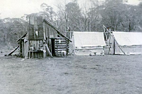
Fig. 1 Moroka Hut Camp
Summer 1954/55
Source: A Webb
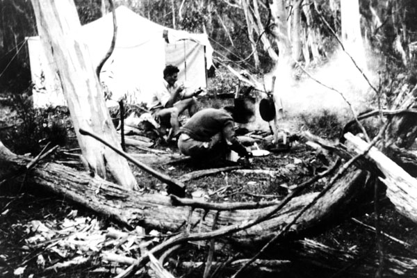
Fig.2 Ross May cooking at Little Round Plain Camp
Summer 1954/55
Source: A Webb
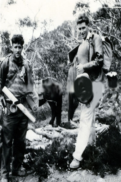
Fig.3 Ray Brash (l) and Arthur Webb heading into Shanty Hollow
Summer 1954/55
Source: A Webb
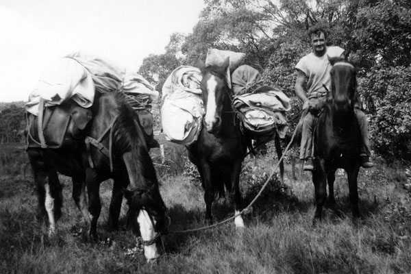
Fig.4 Stuart Hare with Dick and Rose
Summer 1954/55
Source: A Webb
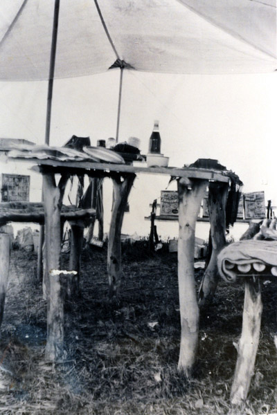
Fig.5 The Mess tent, Surveyors Creek Camp
Summer 1954/55
Source: A Webb
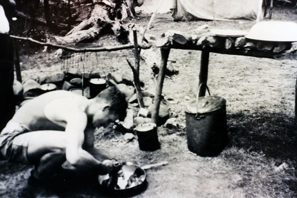
Fig.6 Arthur Webb cooking, Surveyors Creek Camp
Summer 1954/55
Source: A Webb
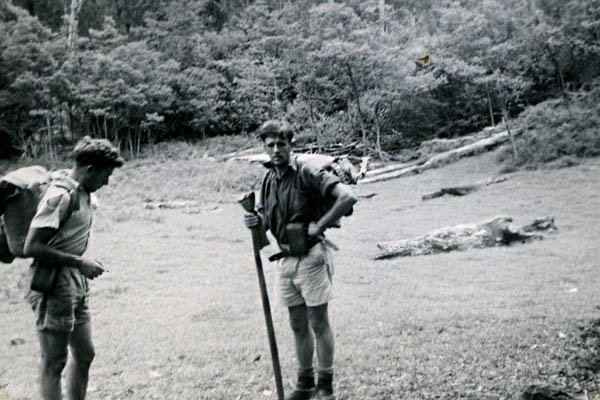
Fig.7 Arthur Webb (l) and Ray Brash at Tali Karng
Summer 1954/55
Source: A Webb
The Mount Selwyn Pack Camp of Summer 1955/1956
The Moroka pack camps of the summer of 1954/55 presented problems on only a couple of occasions, such as at Shanty Hollow and when collecting the botanical specimen for Jim Willis. The rest of the time the relatively flat, wide ridges of the high country stretching from Little Round Plain in the east right across to Mt Tamboritha in the west, was comparatively easy going with few work hazards to contend with.
The Mount Selwyn pack camp, on the other hand, was a tough and, potentially, dangerous job. The Moroka job was a “cake-walk” by comparison.
The Location of Our Pack Camp on Mt Selwyn
Mount Selwyn is located on the Great Dividing Range. The Buckland River starts at the foot of the steep north slopes of the mountain and flows due north to Porepunkah and joins the Ovens River. In 1955 there was one road, more correctly a track, running the length of the Buckland Valley, to finish at Beveridges Flat. A steep, rocky track up a narrow ridge from Beveridges was the access to Mt Selwyn.
The whole area of our assessment job lay within the jurisdiction of Bright Forest District, with Bob Gorman being the District Forester. The Bright office staff would arrange for our food supplies to be delivered to our camp, and Jack Beveridge, local cattle property owner in the Buckland Valley, would provide the necessary pack horses.
The Fire Risk
It was recognized by both Bob Gorman and Murray Paine that should a fire start at the northern end of the Buckland Valley, it would place the crew on Mt Selwyn in danger. There was no way out should an uncontrollable fire start.
Recognizing this danger, it was decided that if there was six weeks without rain, the crew would abandon camp and return to Bright, fire or no fire. As it turned out there was intermittent rain during the job, and we never had cause to abandon camp.
November 1956 - The Job Starts
Bob Orr is the crew leader of a five man crew. The others were Ross May, Bob Allen, Phil King(maybe) and me. Beveridges Flat is our base camp where we leave our Land Rover, other non-essential personal gear and we pack the, now well remembered, pack camp requirements - one 12x12 feet auto-tent, five individual canvas tents and flys, camp stretchers, cooking gear, food, axes, bow saw and, our essential link with the outside world, a TRP battery-operated radio receiver/transmitter.
Jack Beveridge supplies the pack horses and, in this case, riding horses to carry the crew to our camp site. (Fig.8)
The camp site is on the southwest side of Mt Selwyn, beside a spring and a small stream of good water, but overtopped by a stand of mature Alpine Ash. Uphill there are some dead spars. Too bad, no other places with water are available. The tents are pitched, cooking facilities built, the half–wave aerial for the radio is set up, and contact made with Bright. (Fig.9)
The job is to assess the Alpine Ash stands on the ridges leading up to Mount Selwyn, between Mount Selwyn and The Twins to the east, and strips of other eucalypts bordering streams at the bottom of deep valleys falling away from ridges. The stands near The Twins will need a fly camp as they are too far to sample using day trips from the Selwyn camp .The sampling intensity, plot size, and procedures for locating starting points to reach plots were the same as employed for the Moroka job. The same camp organization applied of two 2-man crews to sample the stands each day, and the fifth stay in camp to cook and attend the radio.
Packman Trouble
Our first delivery of supplies is a disaster. Packets of tobacco and papers are swimming in smashed eggs at the bottom of pack saddles. Loaves of sandwich bread are crushed, but fruit arrives OK, as does the tinned food with a few dints. No doubt we were spoiled by the quality of the pack men we had on the Moroka job, where we had no breakages in eggs and other fragile goods. Not much we can do in the present situation other than "suck it up" and get on with the job. No orders in future for eggs and no expectations of bread suitable for lunches.
A Christmas Break then the Job Gets Hard
For the first couple of weeks the work was easy as the nearby stands, situated on the relatively moderate slopes leading off Mt.Selwyn, were sampled. Christmas and approval to leave camp was great but, soon after our return, work started in earnest. The stands to sample were further away from camp and on increasingly steep slopes, and The Twins fly camp was looming.
The crash of a dead spar from above the camp during the night, debris finishing a few feet from our camp, helped to make up Bob’s mind about the fly camp. He and Ross were to shift out as soon as the packman was available. The fly camp was to be a simple structure, a rope stretched between two trees and a canvas fly thrown over the rope, stretched, and pegged to the ground. Bob and Ross would look after The Twins end of the job. We would sample the strips of mixed species. These were along the dry gullies, a long way down from the ridges along which we would walk from our camp under Mt Selwyn.
A Typical Day in the Gully Stands
Bread for lunch was out of the question after it had been flattened before it reached us. There was no water in the gullies at the bottom of long drops off the ridges, and we didn’t have water bottles. Oranges saved the day served as lunch and they gave us something to suck on for moisture.
Lunch break? No way.
Do the sampling and climb back up the steep, never ending slope, to the ridge and then to camp. Absolutely stuffed. (Fig.10)
Fortunately the Selwyn job was of relatively short duration, but it was the toughest of any in my three years of assessing forests while working in the Assessment Branch.
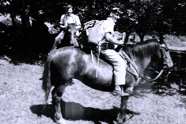
Fig.8 Bob Orr (front) and Ross May heading to Mt Selwyn
Summer 1955/56
Source: A Webb
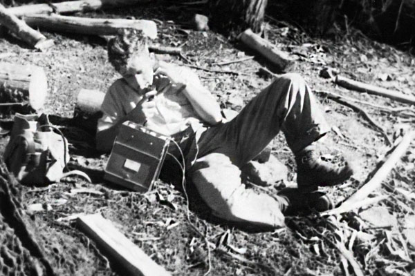
Fig.9 Arthur Webb on the radio, Mt Selwyn
Summer 1955/56
Source: A Webb
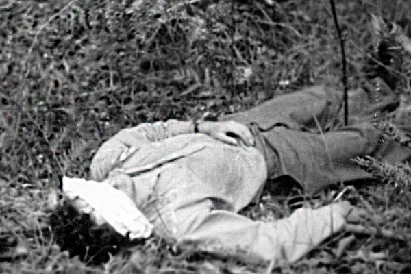
Fig.10 Lying down on the job, Mt Selwyn
Summer 1955/56
Source: A Webb
Looking Back
The experience of working in remote alpine regions was something I remember with complete satisfaction, despite the tough conditions under which we worked on some occasions.
We were isolated from help should there have been a need, but no such need arose, not even a twisted ankle, despite many miles of walking along rough bush tracks and through alpine scrub. Perhaps we were lucky.
We worked in teams and enjoyed harmonious relationships with our fellow team members.
There were no distractions such as telephones, mobiles, landlines, Ipads, nightly TV. None of the distractions we all enjoy(?) today. By today’s standards you might think of us as pioneers, living as we did without things now considered necessary. We were not. Thanks in part to Murray Paine, we were just groups of well–schooled professional fellows, doing a job we loved, who made our own leisure activities, our own fun, and it was great .
I for one do not regret one day, one hour, one minute, of those remarkable pack camps.
See also:
This poem was written by Ray Brash and contributed by Arthur Webb.
